

John Oxley on the Brisbane floods
A bit of Brisbane’s flood history:
| 1824 | John Oxley, early explorer, mentioned evidence of an inundation which he discovered on 19 September 1824 in an area north of the junction of the Bremer with the Brisbane: “the starboard bank an elevated flat of rich land, declining to a point where had evidently by its sandy shore and pebbly surface, been at some time washed by an inundation; a flood would be too weak an expression to use for a collection of water rising to the full height (full fifty feet) which the appearance of the shore here renders possible.” (Ref 2) |
| 1825 | Major Edmund Lockyer mentioned the evidence of a large flood while in the area of today’s Mount Crosby pumping station – “marks of drift grass and pieces of wood washed up on the sides of the banks and up into the branches of the trees, marked the flood to rise here of one hundred feet”. Lockyer’s descendant, Nicholas Lockyer, in 1919 made the following remarks: “the official record of the flood level of the river on the 4th February 1893 at the Pumping Station, the site of which is within a mile of Lockyer’s camp, was 94 feet 10.5 inches. His remarks would seem to suggest that between Oxley’s visit in September 1824 and his [Major Edmund Lockyer] own in September 1825, the river had experienced a flood as great as that subsequently experienced in February 1893.” (Ref 2) |
Source and references: http://www.bom.gov.au/hydro/flood/qld/fld_history/brisbane_history.shtml
More history:
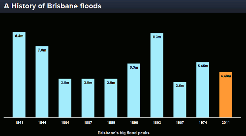
Source: http://www.abc.net.au/news/infographics/qld-floods/peaks.htm
No Comments
No comments yet.
Comments RSS TrackBack Identifier URI
Sorry, the comment form is closed at this time.